Greenhouse Gas Measurements & Modeling

Greenhouse Gas Measurements & Modeling
The California Greenhouse Gas Emission Measurement (CALGEM) project develops strategies to identify and quantify GHG emissions from multiple source sectors. Beginning with initial planning work in 2003, the CALGEM team established tall-tower GHG measurements in collaboration with National Oceanic and Atmospheric Administration (NOAA) in 2007. Since then, the CALGEM team and collaborators have been combining these and other tower measurements with predictions from atmospheric transport models to evaluate the state's GHG emissions inventories of methane and nitrous oxide. More recently, CALGEM expertise has broadened to include quantification of methane emissions from select urban environments (e.g., the SF Bay Area), as well as individual natural gas facilities, homes and businesses.
Anthropogenic Greenhouse Gas Emissions (CALGEM)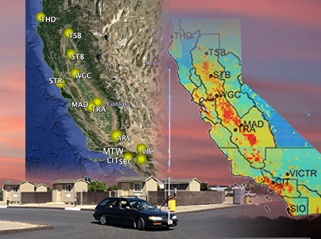
California Greenhouse Gas Emissions Measurement Project (CALGEM) currently comprises a full-scope combination of field sites, measurement instrumentation, and numerical modeling as a user facility for quantification of anthropogenic greenhouse gas emissions of individual facilities to air basin scales.
Measurements
- Long-term field sites outside major urban centers in Central (San Francisco and Sacramento) and Southern California (San Bernardino)
- Continuous full-suite GHG (CO2, CH4, N2O, CO), and/or periodic flask (e.g., 14CO2, 13CO2, 13CH4) measurements
- Mobile field measurement capabilities include instrumented aircraft, balloon borne full column GHG sampling, and mobile plume integrator survey (MPI) instrument
- Laboratory measurements of all major GHGs (CO2, CH4, N2O, CO) and selected stable isotopes (13CO2, 13CH4) for secondary reference gas calibration
Modeling
- Spatiotemporally explicit bottom-up estimates for California methane emissions
- Atmospheric transport simulation using the NCAR Weather Research Forecasts (WRF) at 1 km resolution in domains over California
- Stochastic Time Inverted Lagrangian Transport (STILT) model calculations receptor footprints
- Inverse emissions estimation capabilities including linear and hierarchical Bayesian, as well as geo-statistical inverse models
- Evaluation of predicted transport using wind velocity and boundary layer depth and turbulence data from using network data from radar wind profilers
Support for the CALGEM project has been provided by the:
- Bay Area Air Quality Management District (BAQQMD)
- California Energy Commission, Public Interest Environmental and Natural Gas Research Programs (CEC)
- California Air Resources Board, Research Division (CARB)
- LBNL Laboratory Directed Research and Development program (LBNL)
- University of California Office of the President (UCOP)
- US Department of Energy, Office of Biological and Environmental Research (DOE-BER)
- US National Aeronautics and Space Administration (NASA)
- US National Oceanic and Atmospheric Administration (NOAA)